We deploy lightweight tracked drill rigs and hand augers to collect soil samples across Airdrie’s glacial till and lacustrine clay deposits. These formations, typical of the Calgary-Edmonton corridor, often hide weak layers that trigger slope instability. Before any limit-equilibrium model runs, we need reliable shear-strength parameters from undisturbed samples. That is why our field crew always carries thin-wall Shelby tubes and a pocket penetrometer for quick index checks on site. We also use inclinometer casings to monitor long-term movement when the slope shows tension cracks or bulging toes. Airdrie’s recent development near Nose Creek and the Big Hill Springs area means cut slopes and fill embankments require careful evaluation. We combine this field data with software like Slide2 or SLOPE/W to compute factor-of-safety values under both static and seismic loading per NBCC 2020 ground-motion parameters.
A factor of safety below 1.2 for a residential slope in Airdrie’s glacial till is a clear warning sign that requires immediate geotechnical intervention.
Methodology applied in Airdrie
Risks and considerations in Airdrie
A recent subdivision near 40th Avenue and Yankee Valley Boulevard experienced a slow-moving rotational slide during spring thaw. The failure surface developed along a silt seam within the clay till, roughly 4.5 meters deep. Nobody was hurt, but the developer had to redesign the retaining wall and install horizontal drains. That is exactly the kind of scenario we prevent. In Airdrie, where building lots often back onto natural ravines or constructed stormwater ponds, the consequences of an undetected weak layer can be expensive — cracked foundations, tilted fence lines, even emergency evacuation orders. Our slope failure analysis identifies these risks before construction starts. We model both circular and non-circular failure mechanisms using Spencer’s and Morgenstern-Price methods, and we always check for seismic-induced destabilization. The local bedrock is the Paskapoo Formation, which dips gently eastward; this can create bedding-plane slip surfaces if the overburden is stripped during grading.
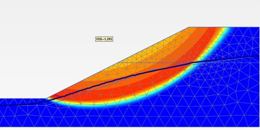
Our services
We offer two complementary services that cover the full spectrum of slope failure analysis in Airdrie.
Limit-Equilibrium Stability Modeling
Using Slide2 and SLOPE/W, we compute factor-of-safety values for circular and non-circular failure surfaces. We incorporate measured pore-pressure profiles from piezometers and apply seismic coefficients per NBCC 2020. The output includes sensitivity analysis on shear strength parameters and recommended slope angles for cut or fill designs.
Site Investigation & Instrumentation
We drill boreholes and install inclinometers, standpipe piezometers, and survey monuments to monitor real-time slope movement. The data feeds back into the stability model, allowing us to calibrate assumptions and update the factor of safety during construction. This service is ideal for Airdrie’s ravine lots and pond embankments.
Common questions
What causes slope failures in Airdrie’s soil conditions?
Most failures in Airdrie are triggered by rapid snowmelt or intense summer storms that saturate the clay till. The low permeability of the till creates perched water tables, reducing effective stress and initiating slip surfaces along pre-existing silt seams or desiccation cracks. Expansive clay behavior also plays a role during wet-dry cycles.
How deep do you typically investigate for a slope stability study?
Depths vary from 3 to 10 meters depending on the slope height and geological setting. For a typical Airdrie ravine lot, we drill at least two boreholes to 1.5 times the slope height. If bedrock or a competent glacial till layer is encountered sooner, we may stop earlier. We log soil continuously and take undisturbed samples at every change in stratum.
What is the typical cost range for a slope failure analysis in Airdrie?
The cost ranges between CA$1.140 and CA$3.710, depending on site access, number of boreholes, and whether instrumentation is required. A basic desktop study with two boreholes and limit-equilibrium modeling falls at the lower end. A full investigation with inclinometers and long-term monitoring reaches the upper end. We provide a detailed quote after a site visit.
Do you provide mitigation recommendations along with the analysis?
Yes. Every report includes practical mitigation measures such as surface drainage improvements, subsurface horizontal drains, soil nailing, or retaining walls. We also include construction sequencing advice to avoid temporary instability during excavation. The recommendations are tailored to Airdrie’s municipal bylaws and the NBCC 2020 requirements.